Educators:This activity is being designed by the
Arizona Mars K-12 Education Program.
Please let us know if it works
well for you in the classroom
2 July 1994
Pathfinder Landing Site Classroom Activity
Modified from TES News, v. 3, n. 2, May 1994
by:
K. S. Edgett
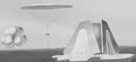
The Mars science community has been asked to help NASA pick a
landing site for Pathfinder. The initial meeting to
discuss landing sites was held in Houston, Texas, on April
18 and 19, 1994. The actual landing site will likely be
chosen soon. (Pathfinder scientists met in
mid-June 1994, and narrowed the list of sites to four).
As an excercise in mission planning, consider in the
classroom where you might land Pathfinder if you had the
opportunity to do so. This activity would be a good follow-up
to class work centered around the GEMS "Oobleck" project or
the Challenger Center "Mars City Alpha" program.
NASA gave the Mars scientists the following
constraints on Pathfinder's landing site:
- Pathfinder must land...
- at 15 degrees plus or minus 15 degrees North latitude
(later narrowed to plus or minus 5 degrees)
- below 0 km elevation
- There is about 150 km uncertainty in the position of the
landing site
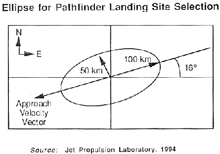
In April 1994, NASA engineers described Pathfinder's landing ellipse
as shown in the diagram above. Courtesy NASA / Jet Propulsion Laboratory.
- Can you answer the following questions?
- Where would you land Pathfinder and why?
- Where did the Viking landers go, and why?
- How do the Viking sites compare with your
proposed Pathfinder site?
- How were the Viking landing sites chosen?
- What were the Vikings searching for?
- Is Pathfinder equipped to look for evidence
of life on Mars?
- Useful additional reference material: a map of Mars---
        Topographic Map of Mars, Map Numer I-2179
        1:25,000,000 scale, (c) 1991.

        from:  U.S. Geological Survey, Map Distribution
                Box 25286, Denver, Colorado 80225
Arizona Mars K-12 Education Program / K.S. Edgett