

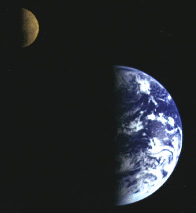
The Earth-Moon System as seen by Galileo in December 1992. Galileo will reach Jupiter in December 1995. Life on Earth would probably be very different were it not for the influence of the tides caused by the Moon. The Moon was first visited by human beings in July 1969. It was last visited by humans in December 1972. (Photo courtesy NASA/JPL).
Click HERE to see the National Air and Space Museum's exhibit of Apollo Moon Mission stuff!
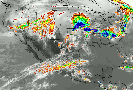
Above is an infrared weather satellite image of the US and Mexico obtained on 27 April 1994. A collection of up-to-date Weather images and data can be obtained from the WEATHER WORLD maintained by the "Daily Planet" of the University of Illinois, Urbana-Champaign.


OZONE DEPLETION ON EARTH.
(A) Chlorine monoxide and ozone abundances over Earth's northern hemisphere in February 1992 and 1993. Maps shows the amounts of ozone at an altitude of 12 km (41,000 ft) above sea level. Maps produced by the Microwave Limb Sounder aboard the Upper Atmosphere Research Satellite (UARS), which was launched in 1991. (Courtesy NASA/JPL).
(B) Chlorine monoxide (left) and ozone (right) over the Antarctic. Ozone abundance is low where chlorine monoxide abundance is high, indicating a link between chlorofourocarbons and ozone depletion. Data from September 1991 and 1992 are compared. Maps produced by the Microwave Limb Sounder aboard the Upper Atmosphere Research Satellite (UARS), which was launched in 1991. (Courtesy NASA/JPL).
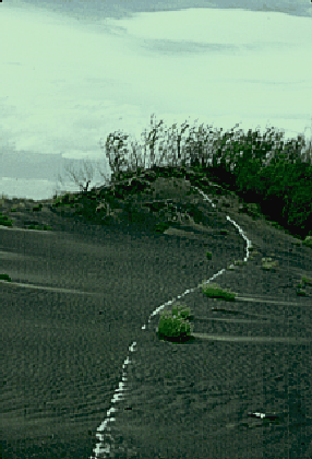

Sand Dunes near Moses Lake, Washington. U.S.A.
These dunes are dark because they are made of mostly basalt sand. Basalt is the dark, iron-rich volcanic rock found in places like Hawaii and Iceland. Much of Central/Eastern Washington State is covered by the Columbia River Basalts. Toward the end of the last Ice Age, these basalts were eroded in the catastrophic Spokane Floods. These floods deposited much sand near Moses Lake; and this sand has since been reworked by wind to make dunes. The white band you see running through the dunes is ash from the 1980 eruption of Mount St. Helens. This white layer marks the location of the 1980 slip-face of the dune. The downwind direction is to the right.
Basalt dunes are rare on Earth but might be common on Mars. These dunes are the subject of study by K. Edgett here at Arizona State University.
(Photos by K.S. Edgett; October 1990)

Sand Dunes in eastern Christmas Lake Valley, Oregon, U.S.A.
People don't often think of Oregon as a place that has deserts, but the eastern half of the state occurs in the rain shadow formed by the Cascade volcanic range. Eastern Oregon is a desert.
Christmas Lake Valley is part of the larger Fort Rock Basin, which during the Ice Ages was a big lake. This lake dried up about 10,000 years ago, with only small ponds forming in the basin since that time.
At the eastern end of this valley occurs the largest active dune field in the State of Oregon. It is known locally as the Shifting Sand Dunes. This dune field has a variety of dune types, including barchanoid (the dune just above the 0.3 km scale bar) and linear (labeled "L") dunes which emerge from sand masses ("M"). North in this photo is to the right. It was obtained by the NASA C-130 Earth Resources program on an overflight in September 1991.