


"Colorized" view of Venus centered on the 0 longitude prime meridian. Compiled from Magellan radar images. (Courtesy NASA/JPL)

Venus north polar view. (Courtesy NASA/JPL).
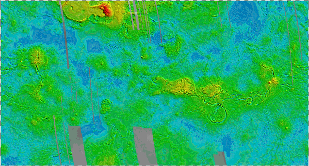
Venus topography. Deep blue represents a planetary radius of 6048 km, dark red (high elevation) is a radius of 6064 km. The average Venus radius is 6051.84 km. The highest area is known as Maxwell Montes. Colored areas from Magellan observations (1990-1993), gray areas from Pioneer-Venus (late 1970's; early 1980's). (Courtesy NASA/JPL).

Computer-generated 3-D perspectives on Venus gravity compared to topography for a region including Beta and Atla Regios. The region shown is 12,700 km by 8,540 km in size, from longitude 180 E to 300 E and latitudes 40 N to 40 S. Beta and Atla are volcanic regions, with both high topography and high gravity. The high gravity is taken to indicate upwelling of molten material, making these volcanic regions analogous to "hot spot" volcanism as seen on Earth in places like Hawaii and Yellostone, Wyoming. Gravity data has been obtained by the Magellan spacecraft between 1992 and 1994. (Courtesy NASA/JPL).