

Excellent Adventure! ASU graduate student Jim Rice sitting on a columnar basalt boulder brought down near Ephrata, Washington, by the catastrophic Ice Age Missoula Floods. Will Mars Pathfinder see boulders like this? Photo by K. Edgett, June 12, 1995.
by Ken Edgett, Arizona State University
"There's going to be fireworks on Mars for July 4th in 1997," Matt Golombek told us while I was driving our rental car up a winding road just south of Spokane, Washington.
"What do you mean, Matt?' Jim asked. Jim and Matt were sitting in the back of the car. Vic Baker was in the front passenger seat, examining topographic maps of the hills. He was looking for a good place to view the entire Spokane Valley, part of a giant channel system formed by catastrophic floods when Ice Age Lake Missoula burst through an ice dam and drained from northern Idaho, across central Washington, down the Columbia Gorge and to the Pacific.
"Well, when it lands, Mars Pathfinder has all these little pyrotechnic devices-- hundreds of them-- that fire to open the tetrahedron, pop up the IMP camera... "
"And there's also the little solid rockets in the parachute back-cover that fire to pull the 'chute out of the way, right?" I said, recalling a NASA diagram of Mars Pathfinder's landing.
"Cool-- we'll remember that this year on the 4th," Jim said.
And we did. ASU Geography graduate student Jim Rice and I spent most of this July 4th at work, putting the finishing touches on a field guide to the Channeled Scabland of Washington. In June, he and I went up to Washington with Dr. Matt Golombek, the Mars Pathfinder Project Scientist from the Jet Propulsion Lab (JPL), and Dr. Vic Baker, a Mars scientist and expert on the Scabland from the University of Arizona. All of this was in preparation for an exciting event that will happen this Fall. Between Sept. 24 and 30, 1995, Mars Pathfinder scientists and engineers, along with other Mars experts from the U.S. and Russia, are going to Washington and Idaho to explore terrain very similar to what we think Mars Pathfinder will see when it lands in Ares Vallis in 1997. We will be joined for field trips Sept. 24-27, workshops Sept. 28-29, and another field trip Sept. 30, by twelve KP12 teachers from schools in Washington and Idaho. (See "Scabland Field Trip" page for more information.)
(article continues below, after figures)
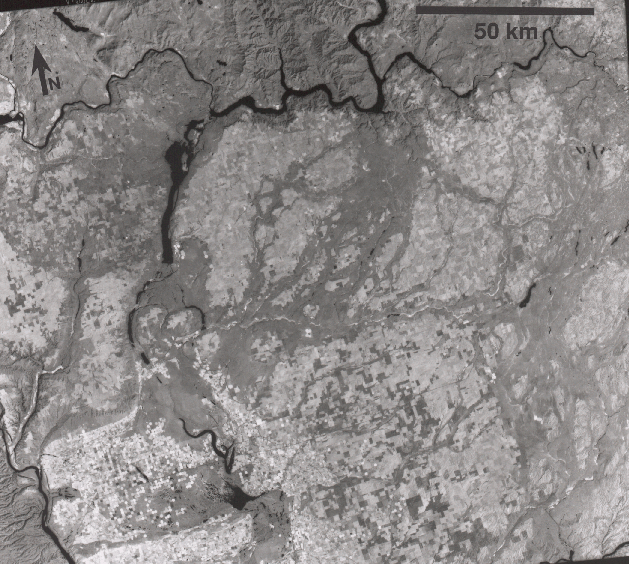
ABOVE: Click on figure to get the full image. This is a Landsat image of the Channeled Scabland of Washington State. This region is the best analog on Earth to compare with the outflow channels on Mars, such as Ares Vallis (see photo below). The Landsat photo was obtained on September 29, 1992, and is centered near 47 degrees 27 minutes North, 118 degrees 49 minutes West. The Channeled Scabland was carved by repeated floods caused by the failure of ice dams which held back glacial Lake Missoula (which covered parts of Montana and Idaho). The last major flood occurred about 13,000 years ago. Water flowed to the southwest (bottom left). Photo from the U.S. Geological Survey EROS Data Center, Sioux Falls, South Dakota, ID No. LM5044027009227390.
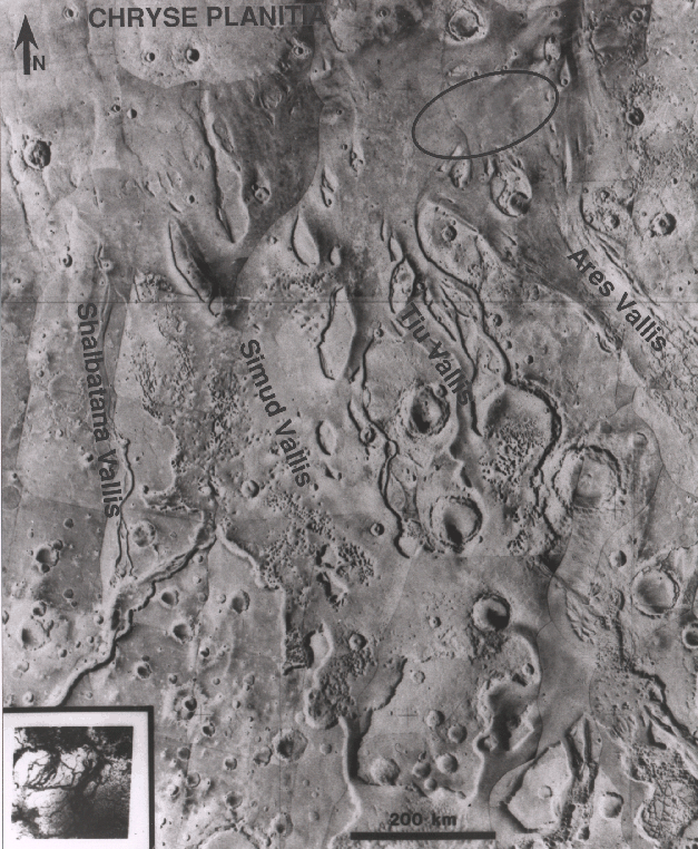
ABOVE: Click on either of above figures to get the full image. The two icon images above are at the same scale and compare a Landsat image of the Channeled Scabland to the region around the Mars Pathfinder landing site.
The outflow channels on Mars were caused by giant, catastrophic floods. Water flowed north. The Mars channels are much larger than those in Washington State. The small photograph in the lower left corner of the full image shows a Landsat image of the Washington Channeled Scabland at the same scale as the Mars photomosaic. Note the ellipse in the upper right corner; it is the Mars Pathfinder landing site region. Compare the Mars Pathfinder landing ellipse with the size of the Scabland in Washington. Compare the small Scabland photo with the figure above that shows a clearer Landsat view of the Scabland. This Mars photo, by Phoenix, AZ, resident Stephen Meszaros, is modified from NASA photograph 84-H-430, available from the National Space Science Data Center, Greenbelt, MD.
On July 4, 1997, Mars Pathfinder will land somewhere within a 200 km by 100 km ellipse centered on 19.5N, 32.8W. The site is a huge deposit of sediment from the Ares Vallis outflow channel. Ares Vallis appears to be similar, though more than 10 times larger, than the Channeled Scabland. The Scabland resulted from catastrophic floods caused by the breaking of an ice dam where present-day Lake Pend Oreille, Idaho, is located. The ice dam created Lake Missoula, which formed of water melting from the Ice Age Cordilleran ice sheet which covered much of Canada more than 13,000 years ago.
The Mars Pathfinder Landing Site Workshop and field trips in the Channeled Scabland are being sponsored by ASU, JPL, the Lunar and Planetary Institute, and NASA Headquarters. The twelve teachers going on the field trips were selected on the basis of proposals they submitted, describing how they will share the experience with students, teachers, and parents in their home communities. Because we can only take twelve teachers, we are looking at ways to extend the educational value by encouraging participation of television and print media. Stay tuned-- we will give a full report on our adventures in Washington in the November 1995 TES News!
 Back to Contents of TES News August 1995