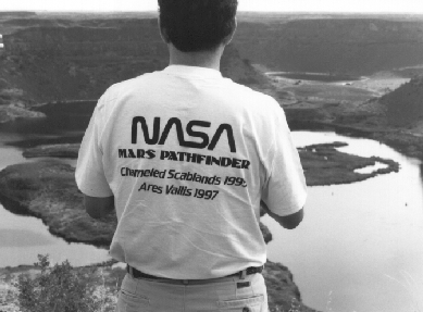
The Ice Age Floods Institute had these commemorative t-shirts available when we were in the Channeled Scabland. Ice Age Floods Institute promotes the history of the Scabland; their address is P.O. Box 122, Ritzville, WA 99169. All photos shown in this article are by K. Edgett, September 24-30, 1995.
by Ken Edgett (ASU)
"This trip shows that Earth is the most Mars-like planet in the Solar System," quipped Jeff Moore of NASA's Ames Research Center. Indeed, the Mars Pathfinder Landing Site Workshop and Field Trips in the Channeled Scabland of Washington proved to be a most excellent experience for the more than 60 engineers, scientists, and educators who gathered to compare Washington with Mars and plan for Mars Pathfinder's July 4, 1997 landing.
"It is exciting that eastern Washington is like the martian landscape!" noted an eighth grade student, Rachel, who came to "Mars Night," a public open house held September 28th to let Spokane residents see what the Mars Pathfinder team was doing in town that week.
It was a virtual invasion of "Martians." The group went to Washington to compare the landscape created by catastrophic Ice Age floods more than 13,000 years ago with the larger Mars flood channel, Ares Vallis. It is in Ares Vallis that Mars Pathfinder will land. The Channeled Scabland of Washington and Idaho represent the best analog on Earth to the channels on Mars.
The September 24-30, 1995, excursion to the Channeled Scabland was an opportunity for Mars Pathfinder scientists and spacecraft engineers to prepare for the Mars landing by evaluating a real, Mars-analog terrain. It was also an opportunity to involve K-12 educators in the process. Thirteen Washington and Idaho teachers joined the group. "We worked side by side with the scientists and engineers as they researched, experimented, problem-solved and debated different aspects of the Mars Pathfinder mission," noted John Gallagher from Port Angeles High School (Port Angeles, WA).
The week's events included four and a half days of field work, two days of scientific workshop, plus a teacher workshop and public open house. These were jointly sponsored by Arizona State University / Arizona Mars K-12 Education Program, the Jet Propulsion Laboratory / Mars Pathfinder Project (JPL; Pasadena, CA), the Lunar and Planetary Institute (Houston, TX), and NASA Headquarters (Washington, DC). The field trips were convened by Ken Edgett and Jim Rice (ASU) and led by Vic Baker (Univ. Arizona, Tucson). The science workshop was convened by Matt Golombek (JPL, Mars Pathfinder Project Scientist). The teacher workshop, held September 27th, was a joint effort between Spokane District 81 and the Arizona Mars K-12 Education Program. The public open house, "Mars Night," held at Chase Middle School in Spokane, was attended by 700 people and was organized by teacher Heather Cassidy.
The field trips began on the morning of September 25th with an overflight of the terrain by half of the group (the other half went the morning of Sept. 26). The air flight proved crucial for helping the field trip participants visualize the flood landforms in their full three-dimensional context and scale. It is very difficult from the ground to tell that the landscape has been carved and cut up by giant floods. It wasn't until geologists had airphotos in the 1930's and 1940's that they began to believe in the flood theory.
The field excursions began after the first flight on September 25. The trips were based out of Moses Lake, Washington. The first day's trek was designed to simulate a trip down Ares Vallis and out into the flood deposits where the landing site occurs (see a Mars map-- the site is located at 19.5 N, 32.8 W). The simulated Ares Vallis trip went down the Lower Grand Coulee from an ancient waterfall site known as Dry Falls. At this location, the National Park Service operates an informative Visitor Center. The group traveled by bus down the coulee (canyon) from Dry Falls out onto a vast flood deposit known to geologists as the Ephrata Fan (named for a nearby town).
The Ephrata Fan was a major attraction, because it is the best analog we were able to find to compare with the place where Mars Pathfinder will land in Ares Vallis. The Ares site was picked because Mars scientists think that it is an area where massive floods have deposited sediment. Hopefully, these sediments include a large variety of different types of rock brought from various locations "upstream" in Ares Vallis.
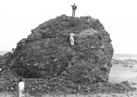
When the Mars Pathfinder engineers first got to the Ephrata Fan, we showed them the worst possible site-- an area with giant boulders, one nearly the size of a small house (see photo below). The engineers responsible for ensuring a safe landing using Mars Pathfinder's airbag system were quite alarmed by the big boulders at this site.
Giant basalt boulder transported by Missoula Floods more than 13,000 years ago. On top of the 59 ft. by 36 ft. by 26 ft. rock is Rob Manning (JPL / Mars Pathfinder Project). The Mars scientists decided that boulders this big are likely to be rare at the Ares Vallis landing site-- this is the largest one in the Scabland Flood deposits and thus represents a worst-case scenario.
The engineers were so startled by the giant boulders on the Ephrata Fan that we decided to alter our field work plans for the next morning, Sept. 26, to return to the Fan. We selected a different site that was within 1/2 mile of the giant boulders, and found that it was pretty good. It looked no rockier than the site where Viking 1 landed in July 1976. Mars Pathfinder engineers have designed the vehicle to be able to land in places that are slightly more rocky than the Vikings landed in.
Our second trip onto the Ephrata Fan showed that most of the Fan is not rocky at all. In fact, most of it has no boulders, just gravel and sand. That night we had a discussion, and the engineers had found the excursion to be very valuable. Mission Design engineer Rich Cook said that "there is a fairly high likelihood that we can handle [the Ares Vallis site on] Mars if the Channeled Scabland is a good analog." Airbag engineer Tom Rivellini was happy to see that most of the rocks transported by big floods, like the Scabland in Washington, are rounded and do not have a lot of "pointy" surfaces that might grab, catch, or tear the airbags.
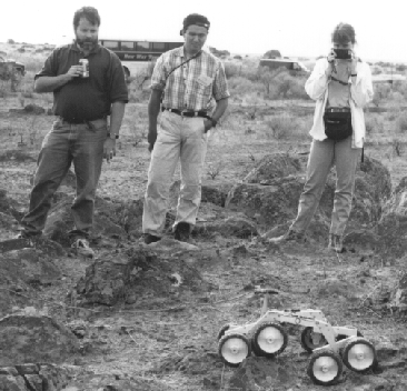
Eight-wheeled prototype of the Sojourner microrover. JPL rover engineer Howard Eisen brought the rover to Washington for field testing. Shown here are Rob Manning (JPL), Goro Komatsu (UA), and Kari Magee (Planet. Soc.).
The workshop participants, in the end, reached a consensus about what the Ares Vallis landing site might be like. All agreed that the site has been affected by multiple giant, catastrophic floods, and that the last floods actually came from nearby Tiu Vallis. Most seemed to agree that the landing site should be no more rocky or hazardous than were the Viking landing sites of 1976. This determination was based on the field work experience, combined with examining new radar data of Mars obtained in 1995 from radio telescopes on Earth, and from looking at Viking orbiter infrared maps. One key infrared map was published in 1986 by TES Principal Investigator Philip Christensen; it is called a "rock abundance" map. The rock abundance map suggests that the Ares site is indeed one of the rockiest surfaces on Mars, but it is no worse than the Viking lander sites, which were also very rocky. The field work on the Ephrata Fan alleviated many fears that the Ares site would be too rocky, because we were able to explore sites that were worse than what the rock abundance map for Mars suggests, and the engineers found that Mars Pathfinder could handle these sites.
The field trips and workshop in support of Mars Pathfinder's landing were a great success. Everyone agreed that bringing together all of the different parties involved with the mission, including educators, made for an invigorating and useful experience. The field work will help Mars scientists interpret the data when Pathfinder lands in 1997. The outreach activities highlight the fact that everyone will be a participant when Mars Pathfinder reaches its destination.
 Back to Contents of of TES News December 1995